Websearch

Custom Search

Nuff

Saturday, May 23, 2009

Reinhold Messner

Reinhold Messner

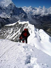
Reinhold Messner in May 2004
Born September 17, 1944 (1944-09-17) (age 64)
Brixen, Italy
Occupation Mountaineer
Website
www.reinhold-messner.de

Reinhold Messner

Biography

Born in Brixen, Italy, and a native speaker of German and fluent in Italian,[1] he grew up in Villnöß and spent his early years climbing in the Alps and fell in love with the Dolomites. His father, Josef Messner, was a teacher. He was also very strict and sometimes severe with Reinhold. Josef led Reinhold to his first summit at the age of five. Reinhold had eight brothers and one sister: he later climbed with his brother Günther and made Arctic crossings with his brother Hubert.

When Reinhold was 13, he began climbing with his brother Günther, age 11. By the time Reinhold and Günther were in their early twenties, they were among Europe's best climbers.[2]

Since the sixties, and inspired by Hermann Buhl, he was one of the first and most enthusiastic supporters of alpine style mountaineering in the Himalayas, which consisted of climbing with very light equipment and a minimum of external help. Messner considered the usual expedition style ("siege tactics") disrespectful towards nature and mountains.

His first major Himalayan climb in 1970, the unclimbed Rupal face of Nanga Parbat, turned out to be a tragic success. Both he and his brother Günther Messner reached the summit, but Günther died two days later on the descent of the Diamir face. Reinhold lost six toes, which had become badly frostbitten during the climb and required amputation.[2] Reinhold has been severely criticized for persisting on this climb with an insufficiently experienced Günther.[3]

While Messner and Peter Habeler were noted for fast ascents in the Alps of the Eiger North Wall, standard route (10 hours) and Les Droites (8 hours), his 1975 Gasherbrum I first ascent of a new route took 3 days. This was unheard of at the time. And similarly his second solo Everest ascent was also done in a short time.

In the 1970s, Messner championed the cause for ascending Mount Everest without supplementary oxygen, saying that he would do it "by fair means" or not at all.[4] In 1978, he reached the summit of Everest with Habeler.[4] This was the first time anyone had been that high without bottled oxygen and Messner and Habeler proved what most doctors, specialists, and mountaineers thought impossible. It changed mountaineering forever. He repeated the feat, without Habeler, from the Tibetan side in 1980, during the monsoon season. This was Everest's first solo summit.

In 1978, he made a solo ascent of the technically difficult Diamir face of Nanga Parbat. In 1986, Messner became the first to complete all fourteen eight-thousanders (peaks over 8,000 metres above sea level).[5] Messner has crossed Antarctica on skis with Arved Fuchs. He authored over 60 books about his experiences, a quarter of which are translated into English and other languages. He was featured in the 1984 film The Dark Glow of the Mountains by Werner Herzog.

Messner today carries on a diversified business related to his mountaineering skills. From 1999 to 2004, he held political office as a Member of the European Parliament for the Italian Green Party (Federazione dei Verdi). He was also among the founders of Mountain Wilderness, an international NGO dedicated to the protection of mountains worldwide.

In 2004 he crossed 2000 kilometres through the Gobi desert. He has now mainly devoted himself to the Messner Mountain Museum, a complex of museums, about several mountain-related themes, of which he is the founder.

[edit] The fourteen 8,000+ peaks

FIRST ASCENT OF MOUNT APO LEADS TO THE BIRTH OF PHILIPPINE MOUNTAINEERING

FIRST ASCENT OF MOUNT APO LEADS TO THE BIRTH OF PHILIPPINE MOUNTAINEERING
Based on the Essay of Fr.Miguel Bernad S.J.
In his book HISTORY AGAINTS THE LANDSCAPE published by La Solidaridad Publishing house in Mannila 1965. He wrote "The 'Snows' on Mount Apo",Bernad Described Mount Apo, (9,689ft - 2,954m) the highest peak in the country, is a very difficult mountain to climb in the 1800s. It drew only the most Didicated and resolute individuals to take on the challenge of threading its Domain and climb its Unclimb summit. Among these men of great resolve is Don Jose Oyanguren, governor of Davao, who organized the first expedition to climb Mount Apo in 1852. In the absence of roads, this expedition approach by way of Tagulaya River. Encountering Thick jungles and hardships, this expedition retreated in failure and 20 members died from exhaustion and perhaps malaria after their return. The second expedition composed of 31 men led by Real, also a governor of Davao,approached by way of Tabon. While it was also defeated, it had no casualty. Don Joaquin Rajal (governor of Davao)together with Fr. Mateo Gisbert and Dr. Joseph Montano (Frenchman) fit the third expedition in 1880. With the help of Datu Manig, one of the chieftains of the warlike Bagobos, this expedition started in Davao on October 6, 1880 and reached the summit on October 10, 1880.Bernad rules that it is the 'first ascent' with implicit reservation. Understandably, the Bagobos enjoys the exclusive domain of the interior, not far from the summit. However, belief on the sacredness, if not frivolous wrath, of Mandarangan, the god of the summit, must have prevailed upon this tribal people not to venture to the summit. In fact, among the Rajal party were 13 Bagobos who, with fear, almost desisted at a point from following the Christians to the summit. One of the Bagobos, a sort of an old sorcerer, told his fellow Bagobo that he had seen Mandarangan leave the crater and fly away in the clouds. Confirming the vision, they then followed the Christians up to the summit.Since the Time Mt.APO is Climbed every major mountains in the Philippines Followed and So The Philippine Mountaineering is Born.
CANLAON IN THE ADVENT OF 2OTH Century RECORD OF FIRST ASCENT In his writings, "The Ascent of Canlaon", Bernad does not pinpoint the date of the first ascent but, nonetheless, suggests that the 'recorded first ascent' of Canlaon (8,085ft) must have occured in the early 20th century. there is no mention of Canlaon in early literature. Under the name Malaspina (after Alejandro Malaspina - a Sicilian nobleman in the Spanish navy), Canlaon appeared for the first time in maps in the 19th century and exists with that name until the early 20th centuty. About this time, Jose de Lacalle (1886) speaks of the dense forest of Canlaon and tells of a party of Englishmen who attempted to climb the crater but died from "exhalations". However, Fr. Miguel Sadera Maso S.J., maintains only one published report of "ascent" before the 20th century. It belongs to Mencarini, a "well-known publicist of the Far East", who has reached the lowest solfataras, which were nowhere near the summit.
Using the papers of Fr. Miguel Selga S.J., Bernad cites, among others, two climbs in the early 20th century implicitly suggesting the 'recorded first ascent'. First, in 1902, Charles S. Banks "climbed" Canlaon with a party of American teachers. Second, in 1916, Echanojauregui, a Spaniard residing in Negros "walked up to the summit". Obviously, for as long as the 1902 climb remains vague with regards to its legitimacy as a consummated ascent , the 1916 climb holds the distinction as the 'recorded first ascent'.
Nevertheless, the true 'first ascent', very likely unrecorded, must have occured long before the known climbs. Historically, the slopes of Canlaon had settlers, composed of Negritos and Malay tribes like the Carolanes, even before the 19th century. No explicit psychological deterrence (i.e. Mandarangan in Apo) could inhibit those early settlers to summit the volcano. Significantly, the recorded climbs of Selga (March 1933), Federico Viaplana (April 1933) and Bernad (1961) are typical of the mountaineering practice of the time. These patrons of mountaineering belong to the gentry who rely on the services of cargadores or porters who doubled as trail guides. By inference, it is not so farfetched to assume that the rest of the Canlaon climbs cited by Bernad could be classified as the 'mountaineering by the gentry'. Regardless of everything, guided climbing is a way of climbing a mountain long before explored by predecessors, some of whom established the trails.
Mount Guiting-Guiting: 1982 The Up Mountaineers claims the first ascent of Mt Guiting-Guiting in 1982.Situated in Sibuyan Is, Mt Guiting-Guiting (6,750ft) remains thickly forested and an intimidating mountain in a remote island. Its summit is craggy and its vegetation in montane grass.
Mount Baloy: 1990s For a long time Mt Baloy (7,049ft), situated in the heart of Panay Is, is held in isolation. It saw intense mountaineering activities in the early 1990s with two clubs attempting to climb it from two sides - the west in Antique and the east in Iloilo province. Naturally, the Antique Mountaineering Society, did carry out its two fruitless attempts from the west. For its part, the Iloilo Mountaineering Club attacked it from the west, for seven days in one of the attempts.. Fortunately, the IMC earned the first ascent in the second attempt With the aid of the locals living in Karatagan, a village at the foot of the mountain, the IMC ascent must have groped their way through the forest in the absence of trails.

1

Mount.Gola

Mount.Gola
Brgy.Sibul San Miguel Bulacan, 196 m.a.s.l.
LEVEL: Easy,Moderate

mt.Gola - Located in brgy. sibul san miguel
bulacan it is part of the Great sierra madre mountain ranges.
locals said gola peak once use by the guerillas fighting the japanese invasion army as camp and a watch tower. a vantage point in spotting the approaching japanese troops..today the place is part of biak na bato national park.


though gola lacks in height it boast several caves and river system to explore, rock jocks and spelunkers are lured by its naturals rock walls. and extensive cave system. the walls are ideal in rapelling too. the trek to the peak take's about an hour and a half (depends in the pacing) trailhead is across the river where the registration is located guides are available all-day (300 to 500 php) depends upon the number of the person in your group the trail is easy passing through cave (madlum cave) with bats hanging at the roof. after the cave you will descend to a river with wonderful rock formation around. the trail is almost level with shade of bamboo tree until you reach the foot of two peaks divided by a river the one in your left across the river halfly covered with second growth forest is mt.gola,

the one in the right is mt.manalmon the peak is 45 minutes away from here via a stiff rocky trail goin up. there is a large campsite before the summit it can accumodate number of tents. the view from the peak provided a 360 of panoramic sites, the vastness of sierra madre, mt.susong dalaga de bulacan and mt.arayat can be seen
DRAWBACKS -

SUGGESTED ITINERARY: (Night Trek)
DAY 1:

5:00PM - ASSEMBLE AT Baliwag bus terminal in cubao (Arrange trip to san miguel)
5:30PM - ETD for San miguel bulacan
8:30PM - ETA Kamias San miguel bulacan (Note:tricycle fee is 50php per head at night time 40php at daytime)
9:00PM - ETA JUMP-OFF (Register get a guide for 300 to 500 php)
9:15PM - Packs on back Start trek
10:15PM - ETA foot of manalmon (rest, snack by the river)
10:30PM - ETD Resume trek
11:15PM - ETA Campsite (pitch tent) rest
11:45PM - lights out -

DAY 2:
6:00AM - Wake up call. (prepare breakfast)
6:30AM - Breakfast, explore campsite and its vantage points
8:00AM - Break camp
8:30AM - PACKS ON BACK Start descent.
9:30AM - ETA Trailhead before the cave. rest,swimming,prepare lunch
11:00AM - Lunch (Picnic style)
11:30AM - ETD Trailhead for Kamias
12:00PM - ETA Kamias (wait for the bus bound to cubao)
3:00PM - ETA Cubao ---- end

1

INFORMATION ON MOUNTAINS IN THE PHILIPPINES

INFORMATION ON MOUNTAINS IN THE PHILIPPINES

Philippine is blessed with numerous mountains that is not only very useful in the economical side but also gives us a thousand and one ways to encounter and enjoy nature. Here are useful list for us to consider. Some are already explored but more are still waiting for us to be explored. Information here are unofficial and based or my own researches on basic books, articles and guides. I don't know if there are already available references from government institutions but hang on and we will keep improving this section.

LIST OF MOUNTAINS IN THE PHILIPPINES BY HEIGHT

Majority of the information here were based on 'Roadmap of the Philippines'. The height of Mt. Pinatubo was reduced from 1780 to 1400 after the Erruption of 1991. There are more than a hundred mountains which are not not yet included in this list. Luzon has three major mountain ranges, Cordillera, Caraballo and the Sierra Madre which is the longest starting from Cagayan and ending in Quezon.


Map of the Philippines

LIST OF MOUNTAINS IN THE PHILIPPINES (BY HEIGHT)
Mt. Apo Davao 2958 meters
Mt. Pulag Benguet 2931 meters
Mt. Tabayoc Benguet 2842 meters
Mt. Amuyao Mountain Province 2702 meters
Mt. Kapiligan Ifugao 2670 meters
Mt. Halcon Mindoro 2585 meters
Mt. Alchanon Mountain Province 2576 meters
Mt. Baco Mindoro 2487 meters
Mt. Saporay Kalinga Apayao 2456 meters
Mt. Malindang Misamis Occidental 2425 meters
Mt. Mayon Albay 2421 meters
Mt. Kitanglad Bukidnon 2379 meters
Mt. Camingingel Mountain Province 2359 meters
Mt. Data Benguet 2310 meters
Mt. Matumtum South Cotabato 2293 meters
Mt. Bandbanglang Kalinga Apayao 2292 meters
Mt. Kalatugan Bukidnon 2286 meters
Mt. Sto. Tomas Benguet 2256 meters
Mt. Sicapoo Ilocos Norte 2234 meters
Mt. Masukut Kalinga Apayao 2223 meters
Mt. Banahaw Quezon 2177 meters
Mt. Lobo Benguet 2138 meters
Mt. Burray Ilocos Norte 2115 meters
Mt. Busa South Cotabato 2083 meters
Mt. Guiting Guiting Sibuyan Romblon 2058 meters
Mt. Nangtud Capiz 2048 meters
High Peak Zambales 2037 meters
Mt. Manmanoc Abra 2022 meters
Mt. Isarog Camarines Sur 1996 meters
Mt. Roosevelt Mindoro 1960 meters
Mt. Cuemos de Negros Negros Oriental 1903 meters
Mt. Mandalagun Negros Occidental 1879 meters
Mt. Lucban de Banahaw Quezon 1875 meters
Mt. Dos Cuernos Isabela 1874 meters
Mt. Balutictic Abra 1860 meters
Mt. Anacuao Isabela 1852 meters
Mt. Hilong Hilong Agusan del Norte 1837 meters
Mt. Cetaceo Cagayan 1833 meters
Mt. Agnamala Ilocos Norte 1786 meters
Mt. Butig Lanao del Sur 1743 meters
Mt. Galintan Davao 1738 meters
Mt. Tangkulang Bukidnon 1678 meters
Mt. Cresta Isabela 1670 meters
Mt. Pasican Davao 1652 meters
Mt. Nausong Aklan 1650 meters
Mt. Dos Huncios Isabela 1613 meters
Mt. Latian South Cotabato 1612 meters
Mt. Iba Zambales 1604 meters
Twin Peaks Cagayan 1603 meters
Mt. Iniaonan Lanao del Norte 1586 meters
Mt. Bulusan Camarines Sur 1559 meters
Mt. Posooy Abra 1540 meters
Mt. Silay Negros Occidental 1535 meters
Mt. Bangbang Kalinga Apayao 1533 meters
Mt. Boragyod Isabela 1512 meters
Mt. Magolo South Cotabato 1450 meters
Mt. Mariveles Bataan 1420 meters
Mt. Pinatubo Zambales 1400 meters
Mt. Lambayo Kalinga Apayao 1386 meters
Mt. Solitario Negros Occidental 1379 meters
Mt. Inaman Antique 1350 meters
Mt. Llorente Antique 1344 meters
Mt. Cuadrado Zambales 1330 meters
Mt. Talampac Abra 1321 meters
Mt. Agilo Bulacan 1315 meters
Mt. Amaloi Bukidnon 1312 meters
Mt. Natib Bataan 1287 meters
Mt. Moises Isabela 1240 meters
Mt. Solu Kalinga Apayao 1238 meters
Mt. Talayan Maguindanao 1226 meters
Mt. Tianlud Bukidnon 1220 meters
Mt. Palanan Isabela 1212 meters
Mt. Hitding Mindoro 1200 meters
Mt. Iriga (Asog) Camarines Sur 1195 meters
Mt. Wayan Kalinga Apayao 1176 meters
Thumb Peak Isabela 1149 meters
Mt. Makiling Laguna 1109 meters
Mt. Lanat Zambales 1106 meters
Mt. Usigen Aklan 1051 meters
Mt. Magnas Kalinga Apayao 1040 meters
Mt. Arayat Pampanga 1030 meters
Mt. Binaca Maguindanao 1021 meters
Mt. Labalasan Cebu 1013 meters
Mt. Razor Back Negros Oriental 991 meters
Mt. Labo Camarines Norte 942 meters
Mt. Mayo Davao 920 meters
Mt. Silangan Zamboanga del Sur 899 meters
Dome Peak Negros Oriental 858 meters
Mt. Capotoan Samar 850 meters
Mt. Toctocan Aklan 842 meters
Mt. Maculot Batangas 835 meters
Mt. Agudo Capiz 834 meters
Mt. Batulao Batangas 811 meters
Mt. Canyaba Samar 796 meters
Mt. Ampira Misamis Occidental 771 meters
Sharp Peak Zamboanga del Sur 753 meters
Mt. Maiyapay Agusan del Norte 719 meters
Mt. Dansalan Zamboanga del Norte 718 meters
Mt. Corobong Maguindanao 716 meters
Mt. Tuburub Kalinga Apayao 694 meters
Mt. Lanibga Cebu 692 meters
Mt. Yacgun Samar 669 meters
Mt. Uling Cebu 659 meters
Mt. Malapantao Negros Occidental 619 meters
Mt. Bingo Samar 606 meters
Mt. Caniapasan Iloilo 594 meters
Mt. Canlaon Negros Occidental 465 meters
Mt. Lantuan Iloilo 453 meters
Mt. Irid Bulacan 448 meters
Mt. Baga Zamboanga del Sur 443 meters
Mt. Engañoso Burias Island 428 meters
Mt. Taquite Zamboanga del Sur 427 meters
Mt. Lanhi Samar 406 meters
Mt. Tres Reyes Zamboanga del Sur 366 meters
Mt. Kabasalar Zamboanga del Sur 391 meters
Mt. Sibugney Zamboanga del Sur 320 meters
Mt. Imbing Zamboanga del Sur 320 meters
Mt. Balatocan Misamis Oriental n/a
Mt. Kapantao Misamis Oriental n/a
Sugar Loaf Zamboanga del Sur n/a
Mt. Dapiak Zamboanga del Sur n/a
Mt. Kaluaya Misamis Oriental n/a
Mt. Kinabalian Agusan del Sur n/a
Mt. Kumakata Agusan del Sur n/a
Mt. Pantado Agusan del Sur n/a
Mt. Buyasan Zamboanga del Norte n/a
Mt. Ampaoid Davao n/a
Mt. Olagusan Davao n/a
Mt. Baluan North Cotabato n/a
Mt. Libadan North Cotabato n/a
Mt. Malibeto South Cotabato n/a
Mt. Matulas South Cotabato n/a
Horse Mountain South Cotabato n/a
Mt. Caumabayan Davao n/a
Mt. Syniop Sultan Kudarat n/a
Mt. Daguma Maguindanao n/a
Mt. Agtuuganan Davao n/a
Mt. Bagumbum Davao n/a
Mt. Initao Misamis Oriental n/a
Mt. Piapayugan Lanao del Sur n/a
Mt. Barambang Lanao del Sur n/a
Mt. Malinao Capiz n/a
Mt. Tago Bukidnon n/a
Mt. Samat Bataan n/a
Mt. Cristobal Quezon n/a
Mt. Blik Maguindanao n/a
Mt. Tauiran Maguindanao n/a
Mt. Sinalagas Bukidnon n/a
Mt. Balingan Bukidnon n/a
Mt. Tangoon Bukidnon n/a
Mt. Kiolong Bukidnon n/a
Mt. Malambo Bukidnon n/a
Mt. Malipuño Batangas n/a
Mt. Cabantian Samar n/a
Mt. Talamitam Batangas n/a
Mt. Hanop Samar n/a
Mt. Lobi Leyte n/a
Mt. Lumes Leyte n/a
Mt. Nacolod Leyte n/a
Mt. Sacroponte Leyte n/a
Mt. Legaspi Surigao del Norte n/a
Mt. Divata Surigao del Sur n/a
Mt. Cadig Camarines Norte n/a
Mt. Malinao Albay n/a
Mt. Micmic Mindoro n/a
Mt. Panucuban Mindoro n/a
Mt. Patrick Mindoro n/a
Mt. Exline Mindoro n/a
Mt. Wood Mindoro n/a
Mt. San Antonio Marinduque n/a
Mt. Sembrano Rizal n/a
Mt. Romelo Laguna n/a

LIST OF MOUNTAINS IN THE PHILIPPINES BY LOCATION


ACTIVE VOLCANOES OF THE PHILIPPINES

There are more than 200 volcanoes in the Philippines. Only 21 of them are active. The list here are taken from the Volcanoes of the Philippines, published by the Philippine Institute of Volcanology and Siesmology.

    ACTIVE VOLCANOES OF THE PHILIPPINES (BY HEIGHT)
    NUMBER NAME LOCATION NO. KNOWN OF ERRUPTIONS
    1 Mt. Mayon Legaspi, Albay 44
    2 Taal Talisay, Batangas 33
    3 Mt. Canlaon Negros Oriental 24
    4 Mt. Bulusan Sorsogon 12
    5 Mt. Ragang Cotabato 9
    6 Mt. Smith Babuyan Island 8
    7 Mt. Hibok Hibok Camiguin Island 6
    8 Mt. Didacas Babuyan Island 5
    9 Babuyan Claro Babuyan Island 1
    10 Camiguin de Babuyanes Babuyan Island 1
    11 Cagua Cagayan 1
    12 Mt. Banahaw Quezon 1
    13 Calayo Bukidnon 1
    14 Mt. Pinatubo Zambales 1
    15 Iraya Batanes unknown
    16 Iriga Camarines Sur unknown
    17 Biliran Biliran unknown
    18 Bud Dajo Jolo Island unknown
    19 Matutum Cotabato unknown
    20 Kalatungan Bukidnon unknown
    21 Makaturing Lanao unknown

* source: Metropolitan Mountaineering Society (MMS)

Samar town finds light in caves

Samar town finds light in caves
By Volt Contreras
Philippine Daily Inquirer
First Posted 02:28:00 05/18/2009

Filed Under: Tourism, Nature

BASEY, SAMAR—When you lose your way in a dark cave, when the lamp finally goes out and panic sets in, you might as well skip all the saints in heaven and directly ask God to speak His famous words: “Let there be light.”

Not food or water, but light, is said to be the most important thing when exploring caves. Compared to other outdoor adventures, like mountaineering or scuba diving, caving seduces with its own set of dangers, mysteries and thrills.

And this town invites you, dares you, to discover them yourself.

For years, Basey’s Sohoton caves—part of an 840-hectare forest area that was declared a national park in the 1930s—have been drawing a modest stream of tourists, hobbyists, researchers and even treasure hunters. Back then, you hire local boatmen and guides, fend for your own lunch, and try to make it back to the city by nightfall—that’s basically it.

Last week, however, the trips to the caves ceased to be a simple come-and-go affair.

Residents offered a “tour package” with add-ons, such as river-cruise meals, trained and uniformed guides, a catering service and overnight lodgings.

Apart from donating equipment like kayaks, overalls, helmets and other safety gear, the Department of Tourism (DoT) last year started training some 60 villagers in this remote municipality on the basics of “visitor management,” eco-tour planning and marketing, food preparation and first aid, among others.

It turned mere guides into engaging storytellers, plain housewives into skilled cooks and project managers, and a laid-back barangay (village) into an energized community.

Alternative livelihood

Two community organizations have since been formed—one to manage the river cruise and the other, the cave tours.

Notably, more than half of the members are women, most of whom had previously known no other trades outside farming and mat weaving.

“We need alternative forms of livelihood since our town had been under commercial logging for over 30 years, when the only ones who got rich were the loggers,” Basey Mayor Wilfredo Estorinos said during the May 11 inauguration of a visitor center in Barangay Inuntan, the main takeoff point for the boats.

Apart from villagers who would be directly employed by the eco-tours, an initial 30 households were willing to provide overnight shelter to visitors, according to Estorinos.

Hours later, he would gamely do the Visayan folk dance curacha to entertain guests on board a wide, twin-hull river craft that serves as the tour’s “floating restaurant.”

Maiden cruise

The newly built boat or lagkaw can carry up to 30 tourists and a crew, including a singer and guitarist. It is said to be more spacious than the vessels similarly used for the Loboc River cruise in the nearby province of Bohol.

The DoT extended a P230,000 grant for the skills training and supplies, while the municipal government allotted a counterpart fund of P100,000 to construct the boat.

On its maiden cruise that day, the lagkaw glided leisurely down the Golden River, where the water wore the pristine tones of greens and browns, where petals—not plastic—dotted the currents.

A separate fleet of pump boats and kayaks took visitors to the Sohoton caves, where tour guides like Richard Alibado applied his training by putting on a good show.

Don’t touch surface

First, Alibado laid down some house rules.

“Don’t touch white surfaces once inside,” Alibado said in Filipino as he briefed visitors at the cave entrance that rainy Monday afternoon.

Oil smears from the human skin are like graffiti that could ruin the natural “growth” of the rocks and cause them to turn brown or black, he explained.

Still confusing your stalagmites with stalactites? Alibado offered a simple tip: The one spelled with the “g” crops up from the “ground,” while that with the “c” hangs from the “ceiling.”

As he led the group deeper into the shadows, Alibado turned from being a mere safety officer into a weaver of fantastic tales.

“What you discover inside caves depends on your imagination; you just have to give life to the rocks,” his prelude went.

Subterranean world

Alibado ticked off scientific terms to describe peculiar rock formations or surfaces.

But in Alibado’s guided tour, the Sohoton caves also became a subterranean world populated by “elephants,” “Ifugao farmers,” “the Holy Trinity,” “astronauts Neil Armstrong and Buzz Aldrin” and even Michelangelo’s “The Pieta.”

“When my friends and I tapped this hollow wall and produced different sounds, we attracted a Philippine Eagle who has never left the cave since. You can actually still see the eagle’s talons to your left,” he said, stringing together one of his many myths.

But the biggest stars, Alibadon said, were the hanging formations just a few feet apart which he teasingly called “Mama” and “Papa.” The Philippine Daily Inquirer leaves it to future Sohoton visitors to find out why.

Continuous walk

Sohoton literally means “to pass through” in Waray. Indeed, one occasionally had to squeeze through narrow openings to get to the different chambers, some cramped and clicking with the noise of bats, others as big as churches.

But exploring Sohoton was quite easy since it required no risky climb or descent, just a continuous walk on mostly level ground.

“That’s why it’s a cave for all ages,” said Karina Tiopes, tourism director for Eastern Visayas.

“Don’t look at me!” said a smiling Tourism Undersecretary Eduardo Jarque Jr.

A jolly promoter who has been with the DoT for the last 32 years, Jarque noted that of the country’s 10,000 caves, only around 300 had been explored.

Tourism Secretary Joseph “Ace” Durano, who like Jarque was here for the inaugural river cruise and cave trek, cited Basey as an example of a community about to perform the delicate balancing act of promoting and protecting its natural wonders.

Durano said the DoT supported the town’s eco-tourism ventures because “we saw that the enabling conditions are here” for that balance to hold, mainly the willingness of the residents and local officials to do their share.

Respecting the caves

Sohoton is just one of the 30 caves found in Basey. To this day, none of them has been vandalized “because the community respects them,” according to Tiopes.

“The belief that spirits dwell in caves also helps keep people out, and the caves are protected that way,” said Jason Garrido, president of the Philippine Cave Guides Association Inc.

Garrido and some 200 other enthusiasts were in Tacloban City in Leyte (30 kilometers from Basey or 45 minutes by car) for the 9th Congress of the Philippine Speleological Society.

The five-day congress, held at the University of the Philippines-Tacloban, assured Basey of tourism visitors for its newly launched projects that week.

Rewards

“Cave tourism in the Philippines is still quite young,” Garrido said.

“Through gatherings like this, we hope to learn the best practices. Most of our caves are still untouched so we can still contain whatever damage had been done.”

Caving, he said, could be more “technically demanding” than mountaineering, “[which involves] climbing, endurance tests and movement skills. But in caving, your primary source of security is light.”

Inside a cave, “you get to feel how small you are in the scheme of things. There would be times when you won’t even see the walls or the ceiling but only the small [illuminated] space around your body. The fear factor is higher.”

But the experience, Garrido said, could be rewarding: “It’s the chance to discover something—like a new species of fish or a secret burial chamber.”

Or maybe even lost treasures? But then, the folks of Basey, by fostering cooperation and turning to eco-tourism as a way out of poverty, may have already unearthed something just as valuable.

Friday, May 22, 2009

Mt. Arayat/ Arayat Trail (1,030+)

MT. ARAYAT (ARAYAT TRAIL)
Arayat, Pampanga
Major jump off: Arayat National Park, Brgy. Bano, Arayat
LLA: 15.20° N 120.742° E, 1030 MASL
Days required / Hours to summit: 1 day / 4 hours
Specs: Minor climb, Difficulty 3/9, Trail class 3

BACKGROUND
The legendary Mt. Arayat rises like a solitary giant over the central plains of Luzon. Long before it drew the attention of hikers, it was already popular in myth. It was said to be dwelling-place of the Kapampangan sun god, Sinukuan. Writer Alex Castro, in "Views from the Pampang", narrates the story: "[Sinukuan] was supposedly imprisoned in a cave sealed with a "white rock" visible on the mountainside." He was engaged on an epic battle with his rival, Apung Pinatubu, who "hurled stones" at Sinukuan. Perhaps this is actually a recollection of Pinatubo's pre-Hispanic eruption, over 600 years ago?

The next legend about Arayat is about Mariang Sinukuan, counterpart of the Tagalogs' Mariang Makiling. In some accounts she was Mariang Makiling's sister, and like her, she was a mountain dweller with fairy-like powers. She was the subject of songs and poems until the present time. Finally, Mt. Arayat is sacred to Rizalistas, who, Castro writes, "gather every December to honor the national hero in quiet ceremonies. The cult was brought to Arayat by the late Apo or Mahal na Inang Birhen Sinukuan in 1947, acknowledged as Rizal's female incarnation."

Thus, whether as a mountain of myth or a towering landmark, Kapampangans take pride in Mt. Arayat. During the 1970s, Mt. Arayat National Park was built - complete with natural pools, picnic areas, and the mountain trail that leads to Arayat's Peak 1. Although the National Park has degenerated into a local resort, it is still the jump-off for Arayat's Peak 1. This peak has a spectacular viewdeck, where you can behold seemingly all of Central Luzon. Pampanga river meanders like a snake across the rice fields; the mountains of Zambales and Bataan come into view; so Sierra Madre on the opposite side.

Meanwhile, Peak 2 can be accessed from Magalang, Pampanga. In either trails, the 'balding' of the mountain is evidenced by the intense heat of the sun. Still, some forests survive and therein, monkeys continue to roam free. You can hear their calls along the last leg of the trail. There are also sightings of wild boar, local civet (musang), and native birds. A separate article for this trail is under construction.

NPA scare continues to scare hikers from climbing Arayat, but there is now military presence in the trails, and the last pockets of NPA resistance were subjugated in 2002. Thus Arayat remains one of the most exciting hiking destinations in Luzon.

ITINERARY
VIA ARAYAT NATIONAL PARK
0500 At Monumento, take bus to Arayat, Pampanga (P120)
0730 ETA Arayat Pampanga. (If private vehicle, take San Simon exit at NLEX)
0800 ETA Arayat National Park; regiser and negotiate (P100 + guide)
0830 Start trek
1200 ETA peak campsite; lunch. You may explore the viewdeck
1300 Start descent
1530 ETA National Park; bathe at the natural pools
1600 Head back to Manila or to Angeles City for sidetrips

SPECIAL CONCERNS
The Arayat N.P. trail has unfortunately gained notoriety for 'extortionist' locals who overcharge everything from entrance to guide fees. In addition they'll even ask for a barangay fee and a parking fee. If you wish to hike Arayat via this route, anticipate these already. The guide fee is P400-500 and don't accept anything higher than that. These charges make an Arayat trip more expensive than it should be. Even then, it is still worth climbing.

Flies, mosquitoes, and other insects abound in Arayat; Off lotion is a must. Also, 50% of the time the trails have no tree cover. The itinerary above is for a daytrip but Arayat is also a good overnight destination. The peak itself is the suitable campsite, with wide spaces for tents and ample shade. At night don't forget to guard or tent-in your belongings as monkeys might take them away.

TRIVIA
Many foreigners climb Mt. Arayat -- and they pay extra. For locals, a guide fee of P500 would suffice, but for foreigners, the guides demand P1,500-P2,000.

Mt. Maculot/Rockies (685+)

MT. MACULOT
Cuenca, Batangas
Jump-off point: Brgy. Poblaction, Cuenca Batanggas
LLA: 13°55'15"N; 121°2'30"E; 685 MASL
Days required / Hours to summit: Half day / 1-2 hours
Specs: Minor climb, Difficulty 2/9, Trail class 1-3


BACKGROUND
Mt. Maculot is one of the most popular daytrip destinations. It is so popular that on weekends and summer months, there is a sari-sari store at the campsite. This mountain, at the heart of Batangas, is known as a landmark for locals and travellers alike; it is easily identifiable because of its abruptly terminating east side - forming a cliff that is challenging for rock climbers and breathtaking to everybody else. Others describe the shape of the mountain as 'igloo-like'.

At 830 MASL, the mountain has three destinations: the grotto, the peak and the rockies (685 MASL). These can all be covered by a traverse dayhike. Most climbers head to the Rockies. This rocky formation stands beside Taal Lake, creating a scenic view, encompassing the whole of Taal Lake including the world-famous Taal volcano; as well the plains of Batangas. From a distance looms, on opposite sides, Mt. Makiling and the Tagaytay Highlands. If you follow Batangas Bay to the South you can see Maricaban Island, and beyond that, Mindoro's Mt. Halcon. The climbing time is variable; experienced climbers can reach the Rockies in a matter of two hours. From the Rockies, one can continue to the peak (830 MASL) or the Grotto on the other side of the mountain. You can also do the traverse vice-versa, starting off at the Grotto and ending at the Rockies. The Grotto area is grassy, but it then the trail becomes forested until it reaches the summit - and down. Either way, the trails are steep but Maculot is one mountain where you can stay the visual rewards are really worth the effort.

ITINERARIES

TRAVERSE
0400 Board Lemery-bound bus from Buendia or Cubao (~P130)
0700 ETA Cuenca Municipal Hall. Either walk or take trike to jump-off
0800 ETA jump-off point, start traverse.
0915 ETA Grotto, take pictures
0930 set out for the peak via forested trail
1200 ETA summit. lunch.
1230 start descent to shoulder campsite and rockies
1430 ETA rockies; take pictures
1500 ETA start descent to mountaineer's store
1620 ETA mountaineer's store; tidy up then head back to the highway for Manila-bound bus

ROCKIES
0600 Board Lemery-bound bus from Buendia or Cubao (~P130)
0900 ETA Cuenca Muncipal Hall. Walk or take trike to jump-off. Pay P10 registration fee.
0930 start trek
1115 arrive at campsite, head to Rockies
1130 at Rockies; take pictures
1200 return to campsite for lunch
1230 start descent
1400 back at jump-off; tidy up then head back to the highway from Manila-bound bus.

SPECIAL CONCERNS
There are no permits required in Maculot and it is generally safe, even for beginners. During April weekends, however, there may be too many climbers. The Rockies is quite small and can only accommodate 30 is sufficient for hiking trips.

Although taking less than 10 minute, the trail from the campsite to the Rockies is very steep. Beginners must be assisted during this leg of the trip.

There are two registration sites: the "tindahan" and the brgy. outpost near the mountaineers' store. You only need to register in either one of them. At times, the registration process is not enforced.

TRIVIA
Batangas folk continue to tell their children that if they don't comb their hair before they sleep, "the kuto (head louse) will take them to Mt. Maculot!". Another variation of this anecdote claims that there's a giant louse that lives in Maculot. It is also said that curly-haired aborigines (Aetas) once lived in this mountain, hence it was named Maculot from "kulot", meaning curly.

There are only a few cases of hiking-related accidents in Mt. Maculot. One, involving a girl climber, was a case of falling from the Rockies followed by his boyfriend in the 1990s.

Mt. Manuggal Tree Planting

FROM MFPI.ORG

Mt. Manuggal Tree Planting
Thursday, 21 May 2009
The Philippine Air Force and the Green Army in cooperation with the MFPI will have a tree planting activity at Sitio Cambagocboc, Balamban, Cebu on May 23, 2009. The activity will see to the planting of 1,000 seedling of fruit-bearing and hardwood trees on the slopes of the said area.

In this regard, we are inviting all Cebu orgs and individuals to be a part of this activity for the greening of mt. manunggal. interested orgs and individuals may confirm their participation to Allan Salazar in order to be listed and be included in the logistics and budget. you may contact allan at 0905-2763403.

Also there is a bill filed on Congress for the renaming of Mt. Manuggal to Mt. Ramon Magysasay in tribute to the late president. This endeavor is being spearheaded by Rep. Teofisto Guingona and Sen. Ramon Revilla.

Just show that mt. manuggal is now in the radar of govt. agencies and we are proud the mfpi is seen as a partner in the cause of mt. manuggal. this is now an opportunity for the members to show our solidarity with their cause. enough politicking already and lets devote our energies to something worthwhile.

for inquiries, you may reach me at 09173006616.

genesis

4th MFPI Luzon Summit

A REPOST FROM MFPI.ORG

4th MFPI Luzon Summit

th MFPI Luzon Summit
Thursday, 21 May 2009
GREETINGS BRETHREN!

This serves as an invitation catering to all mountaineering aficionados, trekkers, outdoor enthusiasts and anybody bound o feel the earth to the FOURTH NORTH LUZON SUMMIT to be held at Sagada, Mountain Province on June 3-7, 2009.

Endowed wit magnificent subterranean caves, inimitable burial sites, cascading waterfalls, awe-inspiring rice terraces, a rich culture and an amiable people, Sagada has doggedly been a major tourist destination in the country for both local and foreign tourist since the 1970’s

Splendid, unscaled mountain sprawl along its crests but some of these remain anonymous destinations.

The Sagada Environmental Guides Association in (SEGA), a duly recognized and accredited by the municipal government as well as the Department of Tourism in partnership with the Mountaineering Federation of the Philippines Inc. (MFPI) together with the sponsors enjoins everyone on this momentous event.

Come and experience, explore, enjoy another chapter or your mountaineering lives in the mountains of the Gran Cordillera mountain range.
See you there!

For more information, visit us at our website http://sega.sagada.org or you can contact 09197856140 or write us under this address owendapliyan@yahoo.com.

Mountaineeringly yours,


EGBERT DAILAY
President

Hendrix

Hendrix
Hendrix

Caloocan Weather Forecast

TopBlogs

Sports & Recreation - Top Blogs Philippines